Show the map
Trail des Bornes 2018 - Le Nature - 16 Bornes
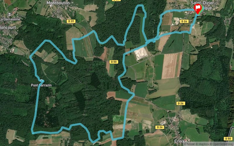


16.4 km
440 m
450 m
 Saint-Dizier-l’Évêque (90)
 Saint-Dizier-l’Évêque (90)
 Points of Interest table
| Accum. | Intermediary | |||||||
|---|---|---|---|---|---|---|---|---|
| POI | Description | Alt. | Dist. | D+ | D- | Dist. | D+ | D- |
 Competition organized on 08/19/2018
Trace n°35888
Ascent threshold : 3 m Distance threshold : 30 m Smoothing : Yes Origin of altitudes : MNT Aster GDEM
Ascent threshold : 3 m Distance threshold : 30 m Smoothing : Yes Origin of altitudes : MNT Aster GDEM
Loop
Dominant terrain : Footpath
Max alti. : 620 m
Avg alti. : 567 m
Min alti. : 510 m
Longest ascent : 100 m
Longest descent : 80 m
Dominant terrain : Footpath
Max alti. : 620 m
Avg alti. : 567 m
Min alti. : 510 m
Longest ascent : 100 m
Longest descent : 80 m
Elevation profile
More tools
Create a new roadbook page
Map and track on your website
Warning ! When you insert a Trace de Trail map on your website, you agree not to hide any element of the module (links to Trail Trail or Trail Connect banner)
Add a realisation
Validate
Add a realisation to share your chrono and describe the conditions that you encountered during you trail running !
Add a comment
Validate
amandine_fati
24/02/23, 17:25:31
bonjour, le tracé est toujours faisable aujourd’hui ? merci par avance ????
24/02/23, 17:25:31
bonjour, le tracé est toujours faisable aujourd’hui ? merci par avance ????
Caroline Tout Court
06/08/18, 12:45:29
Super tracé ! C était la première fois que j utilisais trail Connect . Merci ??
06/08/18, 12:45:29
Super tracé ! C était la première fois que j utilisais trail Connect . Merci ??
Show the infos
Add a track